Where should the Sun be in the sky?
The position of the Sun in the sky is not a fixed point; it is a continuous, dynamic measurement governed by two primary factors: your location on Earth and the time of year. [6] Understanding where the Sun is, or where it will be, is fundamental not just for astronomy but also for architecture, agriculture, and even simple navigation. [7] The Sun follows a predictable arc across our field of vision each day, rising in the east and setting in the west, but the exact angle of this path changes constantly. [5][6]
# Daily Path
Over the course of a single day, the Sun appears to travel along a curved path determined by the observer’s latitude and the time of year. [6] This movement is an apparent one, caused by the Earth's rotation on its axis. [5] For an observer looking from the Northern Hemisphere during the summer, the Sun rises north of east, arcs high in the sky, and sets north of west. [5] Conversely, during the winter months, the path shifts south, rising south of east and setting south of west. [5] The highest point the Sun reaches in the sky during the day is known as solar noon. [6]
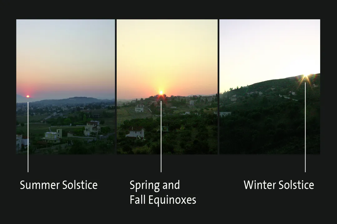
At the equinoxes, occurring around March 20 and September 22, the Sun rises almost exactly due east and sets almost exactly due west, regardless of the observer's latitude (except at the poles). [5][6] This symmetry is a direct result of the Earth's tilt aligning such that the equator faces directly toward or away from the Sun. [5] The path length and the height achieved at noon are also influenced by how close the observer is to the equator; near the equator, the Sun’s path is steep and high year-round. [6]
# Zenith Distance
A critical measurement in determining the Sun's position is its altitude or elevation angle, which is the angle measured upward from the horizon to the Sun. [1][3] Related to this is the zenith distance, which is the angular separation between the Sun and the point directly overhead, the zenith. [6] When the Sun is highest at solar noon, the zenith distance is smallest, meaning the Sun is closest to being directly overhead. [6] For locations near the equator, the zenith distance can be zero or very close to it, meaning the Sun passes directly overhead at certain times of the year. [6] In contrast, observers farther away from the tropics will never see the Sun reach the zenith. [6]
# Seasonal Changes
The primary reason the Sun's path varies so dramatically between summer and winter is the axial tilt of the Earth, which is approximately 23.5 degrees. [5][6] This tilt dictates the Sun's declination, which is the Sun’s apparent angular distance north or south of the celestial equator. [6]
When the Northern Hemisphere is tilted toward the Sun, the Sun’s declination is positive, resulting in longer days and higher solar paths—this is the summer season. [5][6] The maximum northern declination is reached on the summer solstice, around June 21, when the Sun reaches its highest apparent angle in the sky for Northern Hemisphere observers. [6] At this time, the Sun appears to be positioned directly over the Tropic of Cancer ( N latitude) at noon. [5]
Conversely, the winter solstice, around December 21, marks the point when the Northern Hemisphere is tilted away from the Sun, leading to the shortest daylight hours and the lowest solar path. [5][6] At this point, the Sun's declination is at its maximum negative value, and the Sun appears directly over the Tropic of Capricorn ( S latitude) at noon. [5] The equinoxes represent the intermediate points where the Sun is directly over the equator. [5]
An interesting contrast arises when viewing these paths from different hemispheres. If you are in the Southern Hemisphere during June, the Sun will be much lower in the sky, following a path similar to what a Northern Hemisphere observer experiences in December. [5] The Sun's path in the sky is essentially a mirror image between the two hemispheres, switching roles twice a year. [5]

# Locational Dependence
The precise location, defined by latitude and longitude, is the second essential piece of information needed to fix the Sun’s position at any given moment. [1][2][3] While longitude primarily affects the time of solar noon (since it relates to time zones), latitude heavily influences the Sun's maximum height and the length of its arc. [6]
For instance, consider two locations on the same longitude: one near the North Pole and one near the equator. [5] In the middle of summer, the equatorial observer will see the Sun arc high, perhaps only slightly north of directly overhead, offering intense, direct solar exposure. [6] The observer near the pole, however, will experience a very long day where the Sun skims low across the northern horizon, never rising very high above it. [5]
We can create a conceptual model for understanding this difference. Imagine two extreme paths: a polar path where the Sun circles the horizon without setting (during polar summer) and an equatorial path where the Sun passes nearly straight up and down daily. [5] All paths between these extremes are mathematically predictable interpolations between these two behaviors, governed by the observer's specific latitude. [6]
This dependence on exact coordinates is why specialized online calculators exist, allowing users to input their latitude, longitude, and date to receive specific values like solar altitude and azimuth. [1][2][3][4] The azimuth angle describes the Sun’s position along the horizon, usually measured clockwise from true North (). [1][3] A solar noon calculation will always yield an azimuth of (due South) in the Northern Hemisphere, assuming no magnetic deviation, as this is when the Sun crosses the local meridian. [6]
# Positional Calculation Tools
Modern astronomy and solar energy planning rely on precise calculations of the Sun’s position, which requires dedicated tools. [1][4] These tools, available through various online services, take specific inputs to output the Sun's geometric relationship to an observer. [1][2][3]
The required inputs typically include:
- Date and Time: This sets the Earth’s position relative to the Sun in its orbit.
- Latitude and Longitude: These define the observer’s position on the globe.
- Elevation: In some advanced models, the height above sea level can slightly affect refraction, though for most general purposes, standard sea-level calculations suffice. [1][2]
For example, a tool like one found at suncalc.org or suncalc.net can provide not only the geometric position (altitude and azimuth) but also derived times such as civil, nautical, and astronomical twilight, which relate to how high the Sun is below the horizon. [1][3] These tools distinguish between the geometric center of the Sun and the apparent center, which accounts for atmospheric refraction—the bending of light as it passes through the atmosphere, making the Sun appear slightly higher than it geometrically is, especially near the horizon. [5]
When comparing services, you might find slight variations, but the underlying astronomical principles should yield nearly identical results for geometric positions. [1][2][4] The ability to model the Sun’s path for any location and date offers tremendous practical value, contrasting sharply with historical reliance on celestial navigation tables that required extensive manual lookups. [7]

# Practical Solar Awareness
Knowing the Sun's position is more than an academic exercise; it has immediate, tangible applications, from maximizing passive solar heating in a home to positioning solar panels for peak efficiency. [4] For instance, understanding that the Sun is at its lowest arc in winter means that structures must be designed with lower-angled overhangs or larger windows facing the south (in the Northern Hemisphere) to capture that low-angle winter light. [5] Conversely, high summer sun requires shading to prevent overheating. [5]
If you are trying to gauge your location relative to the Sun without electronic assistance, traditional navigation techniques offer a quick check. The Sun’s position at sunrise and sunset gives a general bearing toward east and west, which is only perfectly accurate on the equinoxes. [7] On any other day, the sunrise point will be skewed toward the direction of the current season (north of east in summer, south of east in winter in the Northern Hemisphere). [5]
Here is a quick technique to estimate solar noon based on where you are locally. If you know your time zone is based on a specific standard longitude (e.g., W for Eastern Standard Time in North America), you can calculate an approximate time for solar noon. Since the Earth rotates every hour ( hours), every degree of longitude away from your time zone's meridian equals a four-minute difference from the official clock time. [6] For example, if your local longitude is W and your time zone is standardized to W, you are west of the standard meridian. This means your solar noon will occur approximately minutes later than noon on the official clock time for that zone. This simple conversion allows for a reasonable, non-electronic check on when the Sun will reach its highest point for the day, assuming the date is near an equinox for the best initial accuracy. [6]
# Directional Navigation
The Sun also serves as a compass, a fundamental skill documented in the history of navigation. [7] While an almanac or a celestial tool gives you the precise altitude and azimuth for your specific time and place, basic navigation relies on remembering the general directional rule. [7]
The fundamental rule for the Northern Hemisphere is:
- In the morning, the Sun is in the east.
- At midday (solar noon), the Sun is in the south. [5]
- In the evening, the Sun is in the west. [5]
This rule shifts if you are south of the equator, where the Sun appears in the north at solar noon. [5] The specific angular deviation from due east/west at sunrise/sunset is what causes complications. For instance, if you are trying to walk due east in the Northern Hemisphere in mid-July, you would need to aim slightly north of where the Sun is currently rising, as it is rising north of true east. [5] Relying solely on the general cardinal directions without accounting for the season will lead to positional error over long distances. [7] The precise tools available today eliminate this guesswork by providing the azimuth down to fractions of a degree. [1][4]
# Modeling Path Complexity
To truly appreciate where the Sun should be, one must integrate the daily, seasonal, and geographic variables simultaneously. The interplay between latitude and declination defines the entire geometry of the Sun's visible path.
Consider a fixed latitude, say North.
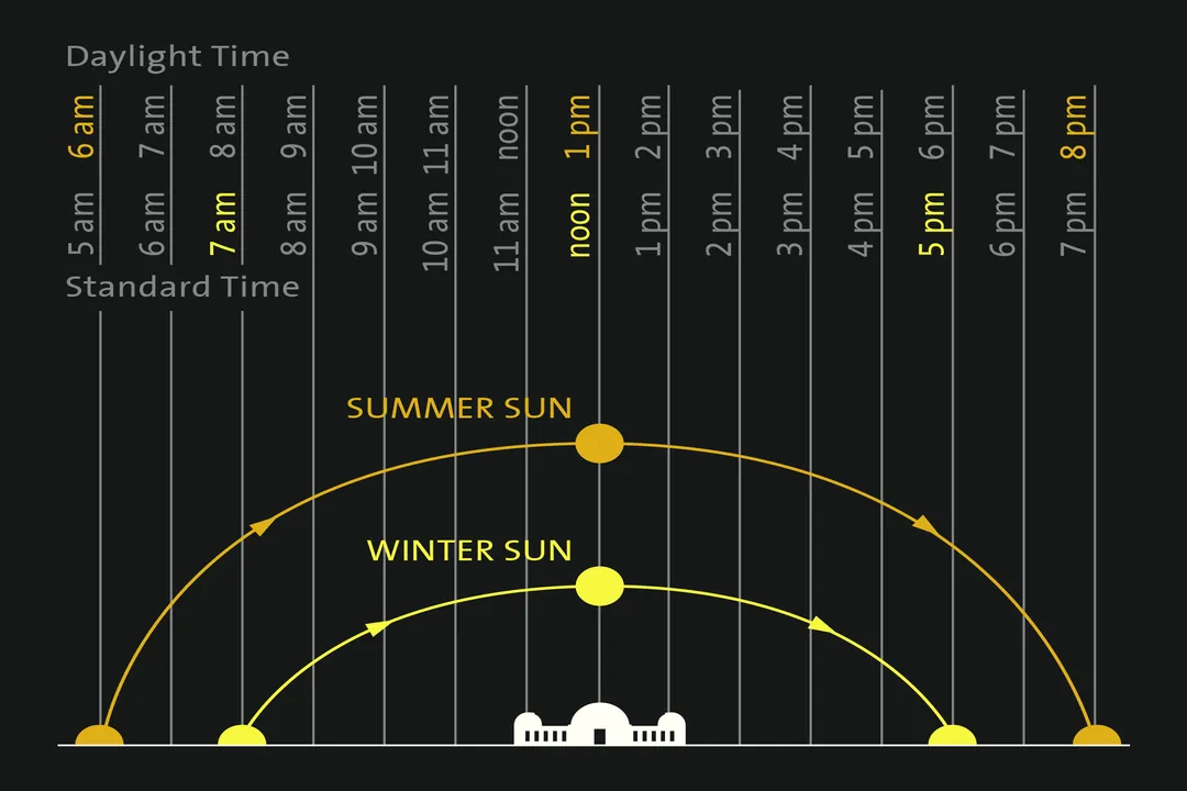
- Equinox (): The Sun rises due East, reaches an altitude of at solar noon, and sets due West. [6]
- Summer Solstice (): The Sun rises further north (north of east), reaches a higher altitude of at solar noon, and sets further north (north of west). [5]
- Winter Solstice (): The Sun rises further south (south of east), reaches a lower altitude of at solar noon, and sets further south (south of west). [6]
This table illustrates how the Sun's highest point changes by nearly 47 degrees between the solstices at this specific latitude. [5][6] The arc length, or the duration the Sun stays above the horizon, is directly proportional to the altitude achieved. [6]
For someone interested in installing a passive solar water heater, this means that the required collector angle (the angle of the collector plate relative to the horizontal) should ideally be set to match the average noon altitude or, more specifically, the winter solstice noon altitude to ensure adequate heating during the darkest part of the year. [4] This practical calculation directly translates the abstract position data derived from Sun path calculators into an actionable engineering specification. [1][4] The difference in solar energy received between summer noon and winter noon at N is substantial due to this change in altitude and the lower sun angle increasing atmospheric attenuation. [5]
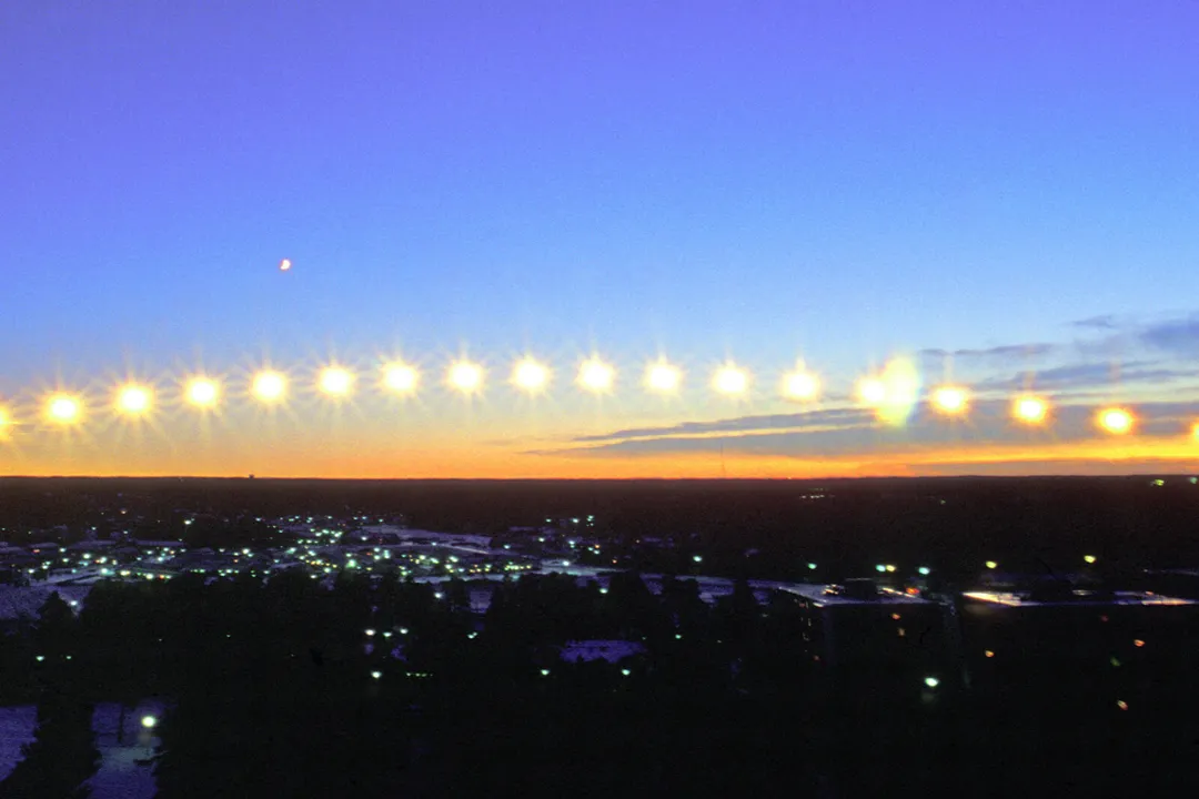
The concept of the analemma, while complex, is the visual path traced by the Sun at solar noon throughout the year when plotted on a map. It's a figure-eight shape that captures the Sun’s yearly deviation from the celestial equator due to the eccentricity of Earth's orbit combined with the axial tilt. [6] While the daily path is a simple arc on any given day, the sequence of those daily arcs forms this subtle, yearly pattern, demonstrating that the Sun's position is not only governed by the rotation and tilt but also by the slight non-uniformity of Earth's orbit around the Sun. [6]
In summary, locating the Sun in the sky requires establishing a precise reference system using latitude and longitude. From there, the time of day dictates the current angle along that day's arc, while the date sets the tilt relative to the Sun, modulating that arc's height and compass bearing. [1][5][6] Whether using sophisticated online computation tools or relying on ancient observational methods, the Sun’s location is a knowable, predictable element of our environment. [7]
Related Questions
#Citations
SunCalc - sunrise, sunset, shadow length, solar eclipse, sun ...
Calculation of sun's position in the sky for each location on ...
SunCalc - sun position, sunlight phases, sunrise, sunset, dusk ...
Sun Direction: orientation of the sun throughout the day
Sun & Stars Paths
Sun path
The Sun: Complete Information & Live Data
How to navigate using the Sun