How do plate tectonics shape Earth’s surface?
The dynamic processes occurring deep beneath our feet are the primary architects of the world we see above ground, dictating the location of oceans, the height of mountains, and the distribution of geological hazards. This grand architecture is governed by the theory of plate tectonics, which posits that Earth’s rigid outer layer, the lithosphere, is broken into several massive, interlocking plates that are constantly in slow motion relative to one another. [1][4] These movements, though gradual on a human timescale, have reshaped continents and ocean basins over hundreds of millions of years. [8]
# Shell Structure
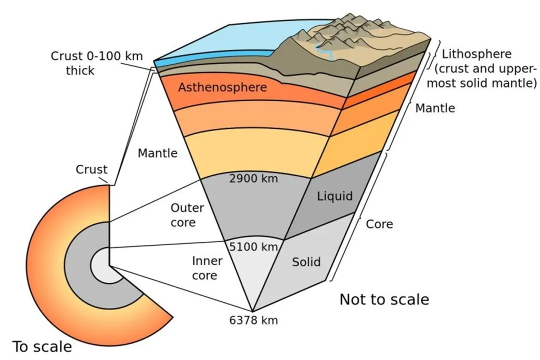
To understand how these plates shape the surface, it helps to visualize the Earth’s structure. The outermost solid layer is the lithosphere, which includes both the crust and the uppermost, rigid part of the mantle. [1][3] This lithosphere is not a single continuous shell; instead, it is fractured into these large tectonic plates. [1][4] Beneath the lithosphere lies the asthenosphere, a layer of the mantle that is hotter and more ductile, allowing it to slowly flow. [3][5] The rigid tectonic plates essentially "float" or glide across this softer layer. [5] The formation of these plates themselves involved processes related to the cooling and differentiation of the early Earth, where distinct, less dense plates eventually formed atop the hotter interior material. [9]
# Mantle Engine

The energy source driving this massive planetary reorganization comes from within the planet itself. Heat escaping from the Earth’s core creates slow, powerful currents within the mantle rock. [2][6] This process, known as mantle convection, acts like a giant, slow-moving conveyor belt. [2][4] Hotter, less dense material rises toward the surface, cools near the lithosphere, and then sinks again as it becomes denser. [3][5] These rising and sinking motions drag the overlying tectonic plates along, making the mantle convection system the fundamental mechanism responsible for plate movement. [2][5]
Consider the incredible disparity in speed. While we perceive the ground beneath us as completely stable, these plates are currently moving at rates comparable to how fast human fingernails grow—just a few centimeters per year. [4] An interesting comparison arises when we look at geological time: if a continent moves at just $2$ centimeters per year, it travels about $200$ kilometers in a million years. This means that the arrangement of continents visible in maps today, like the Atlantic Ocean, is merely a temporary configuration in a perpetual, slow-motion reorganization of the planet’s surface that has been ongoing since the time of Pangaea. [8]
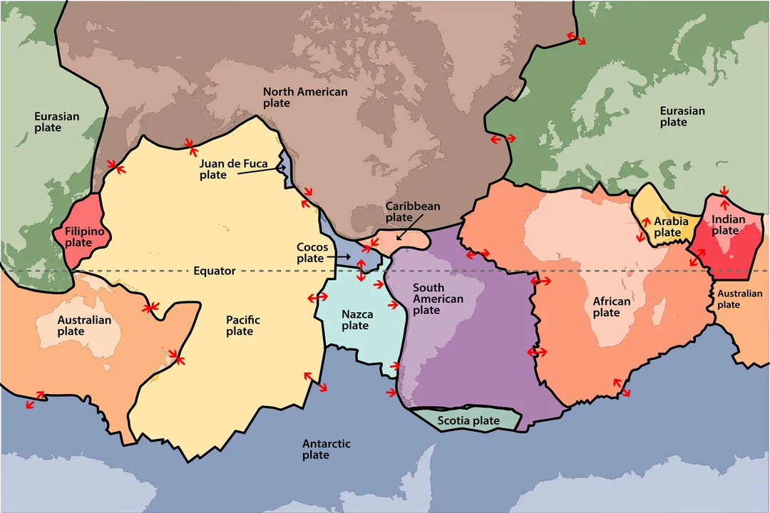
# Boundary Interactions

The most dramatic surface reshaping occurs where these moving plates meet, which geologists categorize into three main types of boundaries based on their relative motion. [1][4][5]
# Divergent Zones
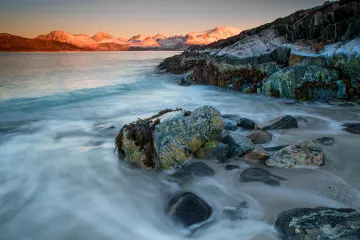
At divergent boundaries, plates move away from each other. [1][6] This separation pulls the lithosphere apart, creating a gap that allows hot magma from the mantle to rise, cool, and solidify, thereby creating brand-new oceanic crust. [4][6] This process is known as seafloor spreading. [1] The most extensive examples of this process are the mid-ocean ridges, vast underwater mountain chains that snake around the globe. [1] Iceland, for instance, provides a rare chance to see a divergent boundary above sea level, as it sits atop the Mid-Atlantic Ridge. [7] The continuous creation of new seafloor here pushes older crust away from the ridge crest, constantly widening ocean basins. [8]
# Convergent Zones
Where plates collide, the result is often dramatic surface deformation. [1][6] The outcome depends heavily on the types of crust involved. When an oceanic plate meets a less dense continental plate, the denser oceanic plate sinks beneath the continental plate in a process called subduction. [1][4] This sinking slab drags ocean floor down into the mantle, forming a deep-sea trench, which represents the deepest parts of the ocean floor. [1] As the subducting plate descends, trapped water and heat cause the overlying mantle wedge to melt, generating magma that rises to form chains of volcanoes on the overriding plate, like the Andes Mountains. [4]
If two continental plates collide—neither being dense enough to subduct easily—the immense compressional forces cause the crust to crumple, shorten, and thicken, uplifting massive mountain ranges. [1][4] The Himalayas, formed by the ongoing collision between the Indian and Eurasian plates, serve as the planet’s preeminent example of continental collision. [1]
# Transform Zones
The third type of boundary involves plates sliding horizontally past one another. [1][6] This is neither creation nor destruction of crust, but rather intense friction and shear stress along the boundary. [4] While these zones do not build mountains or open oceans, they are seismically very active. The grinding action causes tremendous stress to build up, which releases suddenly as earthquakes. [5] The San Andreas Fault in California is a famous example of a transform boundary, where the Pacific Plate slides northwest relative to the North American Plate. [5]
# Surface Sculpting
The three boundary types directly account for virtually all of Earth’s major surface topography and geological activity. [4]
# Mountain Building
Mountain ranges are direct consequences of the immense forces generated at convergent boundaries. [1] Continental collision zones, as mentioned, create the highest, most complex mountain systems when two masses of continental crust meet and buckle upwards. [1] Even subduction zones contribute to uplift, as the compressional forces associated with the sinking slab cause the overriding continental margin to uplift and deform. [4]
# Volcanoes and Earthquakes
Volcanic activity is intrinsically linked to plate movement, primarily occurring at divergent boundaries (where magma rises to fill spreading gaps) and convergent boundaries (where subduction generates melt). [7] The Pacific Ring of Fire is a classic example, tracing the boundaries of many subducting plates where magma fuels arc volcanoes. [4]
Earthquakes are the sudden release of strain accumulated by plate interactions. [5] While they occur at all boundary types, the nature of the earthquake—its depth and intensity—is often predictable based on the boundary type. Along subduction zones, for instance, the friction between the descending slab and the overriding plate can cause massive, deep earthquakes. This leads to an interesting consideration for hazard assessment: the angle at which a plate subducts directly influences how far inland and how deeply seismic energy might penetrate the overriding crust. A very shallow angle of subduction means the plate interface remains close to the surface for a greater horizontal distance inland, potentially placing populated areas at risk from deeper, yet powerful, tremors compared to a steep subduction zone that quickly plunges below the crust. [2]
# Trenches and Rifts
At the other end of the spectrum from mountains are the deepest features on Earth: the ocean trenches. These abyssal plains are carved out where oceanic lithosphere is recycled back into the mantle. [1] Conversely, divergent boundaries create rift valleys, like the East African Rift, where the crust is being pulled apart, beginning the process that may eventually lead to a new ocean basin. [7]
# Global Context
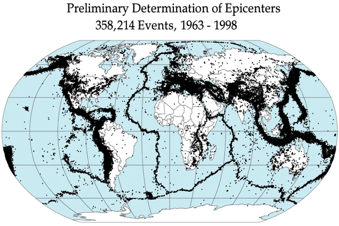
Plate tectonics is more than just the study of rocks and earthquakes; it is the unifying theory explaining the large-scale arrangement of the planet’s features. [4] It explains why earthquakes and volcanoes are not randomly scattered but instead cluster along relatively narrow, linear belts that outline the edges of the plates. [5]
The process of seafloor spreading at mid-ocean ridges implies that the Earth’s surface area is not expanding significantly; rather, new crust formed at the ridges is balanced by old crust being destroyed at subduction zones. [1][6] This continuous cycle of crust creation and destruction—a recycling system—is what keeps the number of plates roughly constant and maintains the surface area of the continents over geological timescales. [9] Without this recycling mechanism, the planet’s surface would look drastically different, with crust only accumulating, leading to perhaps a single, massive continent perpetually growing without oceanic basins to separate it. [8] The balance between creation and destruction allows for the dynamic geography we observe today.
Related Questions
#Citations
Plate tectonics
How Mantle Movements Shape Earth's Surface - Eos.org
Plate Tectonics
Plate Tectonics - National Geographic Education
Plate Tectonics
How do plate tectonics shape Earth's surface? A. The ...
Using the Diagram to Discuss How Plate Tectonics Works
Continental Movement by Plate Tectonics
How were the tectonic plates formed? : r/askscience