How does erosion shape landscapes?
This dynamic planet we inhabit is never static; its surface is in a constant state of flux, sculpted by forces both subtle and overwhelming. At the heart of this ceaseless transformation are the interrelated processes of weathering and erosion, which together dictate the features we see, from towering mountains to deep, winding canyons. [1] Understanding how these forces operate is key to appreciating the very structure of the Earth beneath our feet.
# Weathering Erosion Link
The shaping of any given landscape is fundamentally dependent on two main processes working in tandem: weathering and erosion. [1] It is essential to recognize the distinction between them, as they represent sequential steps in land degradation. Weathering is the in-place breakdown of rock material, essentially converting solid bedrock into smaller, weaker fragments, or "crud". [1] Erosion, by contrast, is the removal and transportation of that weathered material. [1] If weathering is the preparation of the raw material, erosion is the transportation system that carries it away, exposing fresh rock to begin the cycle anew. [1]
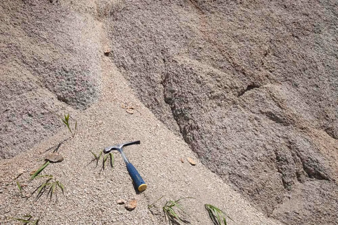
Weathering itself occurs via two primary mechanisms: physical and chemical. [1] Physical weathering involves the mechanical fragmentation of rock—the actual breakage caused by factors like ice wedging (where freezing water expands cracks), root growth, or thermal expansion during intense heating events such as fires. [1] This process increases the surface area available for chemical reactions. [1] Chemical weathering, conversely, alters the rock’s composition, a process critical for the creation of soil. [1] Key chemical actions include oxidation (rusting of iron-rich minerals), dissolution (especially of limestone), and hydrolysis, which turns minerals like feldspar into clay. [1] Chemical weathering is notably more active in warm, wet climates and less so in cold, dry ones. [1]
The two weathering types often assist one another: physical breakdown creates more surface for chemical attack, while chemical weakening softens the rock, making it easier to fracture physically. [1] This intricate dance between breaking down and moving away dictates the initial conditions for every major landform.
# Agents of Removal
While weathering sets the stage, it is the agents of erosion that actively reshape the terrain by moving the debris. [1] The most significant influence driving these removal processes is gravity. [1] Gravity is the engine behind mass wasting events, such as rock falls, avalanches, and debris flows, where loosened material moves from high ground to low ground. [1] Landslides are a direct example of gravitational erosion.
However, gravity rarely acts alone; its power is often facilitated by water. [1] Water, in its various forms—rain, rivers, oceans, and glaciers—is arguably the most pervasive sculpting agent overall, despite gravity being the ultimate driver. [1] Wind also plays a part, though it is considered a relatively minor contributor because it can only effectively transport the finest particles, like dust and sand. [1]
The six main erosion processes often operate in concert: gravity, wind, rain, rivers, oceans, and glaciers.
# Water's Power
Water, in its liquid form, is a tremendously powerful shaper of the surface. Rain initiates erosion through rain-splash erosion, where falling droplets dislodge weathered material like soil or pebbles. Heavy rain or rapid snowmelt then carries this dislodged sediment into streams and rivers, starting the fluvial erosion process.
Rivers and streams erode downward and sideways, carving out watersheds where the gradient is steep, while simultaneously building up floodplains where the land flattens out. A classic example of river power is seen in meandering rivers. As a river winds across flat land, the water moves faster along the outside bank of a curve, giving it more energy to erode the ground there, deepening the curve. Conversely, the water on the inside curve moves slower, depositing its carried sediment, which builds up the inside bank. This action causes the meander to expand sideways, creating deeper bends over time.
Oceans demonstrate a different scale of hydraulic action. Waves constantly rework coastlines, eroding loose beach sand through the cyclical motion of tides and swash. Ocean currents also remove sand washed off the beach and deposit it elsewhere, causing one stretch of coastline to retreat while bolstering another down-current. This continuous redistribution shapes the evolving shoreline naturally.
# Ice and Air
Glaciers, described as very slow-moving rivers of ice, have the capacity to weather and erode entire continents or sculpt mountain valleys due to their immense size and weight. As glacial ice flows, its sheer weight, combined with the rock debris embedded within it, grinds away the underlying bedrock, picking up even more material along the way. When these glaciers melt or break off, they deposit this mixture of rock, sand, and clay, often creating distinctive landforms at their terminus.
Wind erosion, sometimes called aeolian erosion, acts much like natural sandpaper. When carrying sand and dust, the wind sculpts exposed rock by blasting it with these abrasive particles. Anything directly in the path of wind-blown sediment is slowly worn down, and the freed material is then transported to a new location.
# Rock Type Influence
The final shape of a landscape is not solely determined by the intensity of weathering and erosion but critically by the material being acted upon. [1] The underlying bedrock acts as the initial block that weathering and erosion carve. [1] Therefore, the landscape's appearance is inextricably linked to the type of rock and its structure—its orientation, fracturing, and relationship to surrounding rock types. [1]
This relationship leads to the principle of differential erosion: some rock types resist erosion and stand out as topographic highs, while others are easily weathered and removed, forming topographic lows. [1]
# Resistance Factors
A crucial factor in determining a rock's resistance is its ability to repel water. [1]
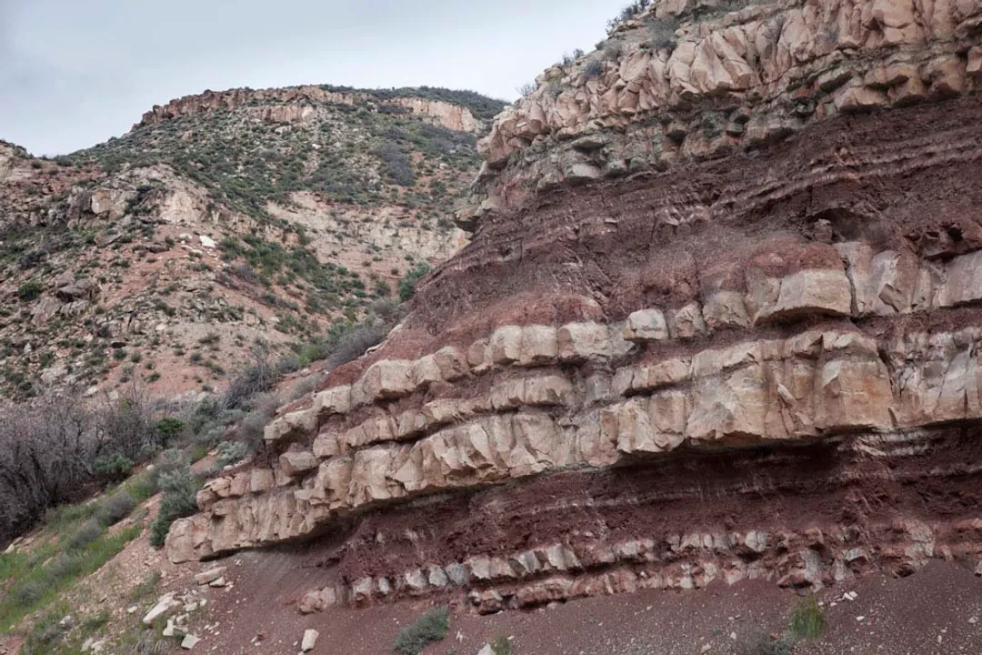
- Sedimentary Rock: The presence of bedding planes (layers) allows water penetration, thus decreasing resistance. [1] Stronger cementation between grains increases resistance. [1]
- Grain Size: Coarser-grained rocks generally offer less surface area for a given volume, tending to increase resistance compared to finer-grained rocks. [1] For example, sandstone beds, being coarser than underlying shale or mudstone, often form resistant cliffs. [1]
- Metamorphic Rock: Foliation (layering in metamorphic rock) also promotes water penetration, reducing resistance. [1] Crystalline structures, however, tend to increase resistance. [1]
- Carbonate Exception: Rocks like limestone present an interesting variable. They are resistant in arid settings but become easily dissolved and therefore less resistant in wetter climates. [1]
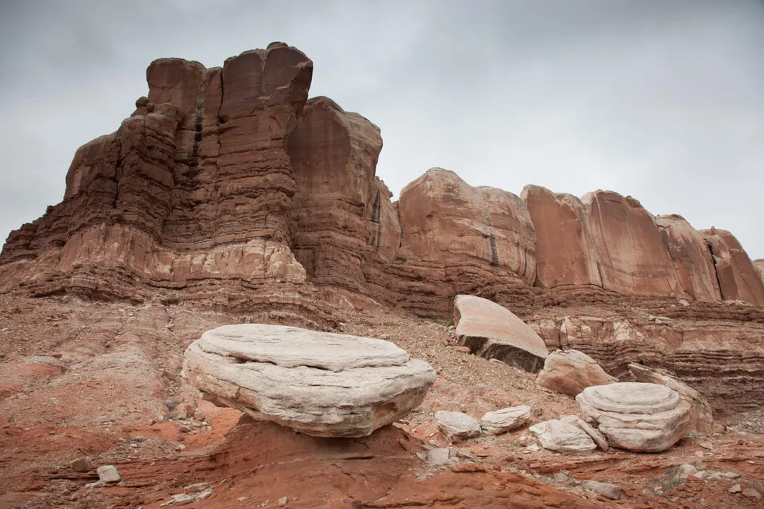
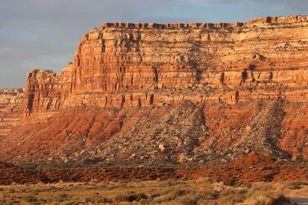
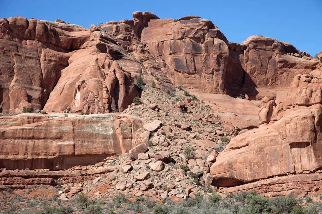
When examining flat-lying sedimentary sequences, like those in the Colorado Plateau, this differential erosion creates a predictable pattern: resistant layers form prominent cliffs, while easily eroded layers form gentler slopes beneath them. [1] Gravity often completes this picture, as undercutting of the cliff base by slope erosion leads to large blocks falling, resulting in talus cones at the base of the cliff face. [1]
If the rocks are tilted rather than flat, the resistant units form ridges, and the weaker ones form valleys, with the ridges often being asymmetric. [1] The dip-slope side, parallel to the bedding, slopes gently, while the opposite side forms a steeper cliff or ledge. [1]
# Structural Control and Landforms
The internal structure of the rock mass, particularly fractures and faults, directs erosion, especially where water flow is concentrated. [1] Fault zones are often zones of weakness because movement along them can crush the adjacent rock, making it significantly easier to erode. [1] Consequently, faults and fracture zones frequently dictate the location of features like canyons and valleys. [1]
Consider the slot canyons found in parts of Utah: these form when vertical fractures, which allow localized water flow, erode into narrow chasms, leaving the unfractured rock standing as narrow ridges called fins. [1] Over time, erosion acting on the sides of these fins can lead to the formation of arches. [1] Similarly, major structural features like the San Andreas Fault in California have dictated the orientation of features, such as Tomales Bay, which protrudes inland along the fault line. [1]
When considering an arid landscape like the Colorado Plateau, the interplay between rock structure and fluvial action becomes evident in entrenched meanders. [1] A river, perhaps following a steady path established when the land was flat, continues to cut downward as the entire region experiences uplift. [1] The river maintains its winding course, but now it is deeply incised into the bedrock, creating a "stair-stepped" topography down to the water level, reflecting the alternation between resistant cliff-forming rocks and softer slope-forming rocks. [1]
It is interesting to observe how lava flows, which often settle into large, relatively flat sheets, can mimic the topography created by flat-lying sedimentary layers, forming vast plateaus that are later incised by deep canyons, as seen in areas like the Snake River Plain. [1]

# Insight into Landscape Evolution
The pace at which these processes occur is fundamentally tied to climate and human activity, though the sources mainly focus on the mechanisms. [1] If we look at the slow, steady grinding of a glacier versus the sudden, catastrophic failure of a landslide, we see that landscape evolution operates on vastly different timescales. [1] A key analytical point, often overlooked in simple definitions, is the concept of equilibrium in fluvial systems. A river system only appears stable when the rate of material removal (erosion) perfectly balances the rate of material supply from the weathering processes upstream and above the channel. [1] When this balance is upset—say, by massive deforestation on a steep slope leading to a sudden influx of sediment—the river's equilibrium is destroyed, causing it to rapidly adjust its channel shape, often through severe bank erosion on the outside curves until a new balance is achieved.
Furthermore, while the processes are universal, the expression of these processes can be highly localized based on human land use, which accelerates or mitigates natural rates. For instance, in newly developed suburban areas where native vegetation is stripped for construction, the soil, previously protected from rain-splash erosion, becomes highly vulnerable. A heavy rainstorm can mobilize soil that might have taken millennia to erode naturally, leading to temporary, highly visible gullies that drastically alter local drainage patterns until stabilization occurs. This localized impact highlights that while geology dictates the potential for landscape change, contemporary environmental factors often dictate the rate of change we witness in a human lifetime.
# Landforms Summary
The combined action of differential erosion guided by rock type and structure, driven by gravity and facilitated by water, creates the recognizable landforms we study:
| Landform Feature | Primary Sculpting Mechanism(s) | Key Rock/Structural Control |
|---|---|---|
| Canyons/Valleys | Fluvial Erosion, Glacial Scouring, Gravity | Faults, joints, and alternating hard/soft horizontal layers [1] |
| Hogback Ridges | Differential Erosion | Tilted, resistant rock layers alternating with weak layers [1] |
| Arches/Fins | Fluvial Erosion along fractures | Vertical joint sets that permit focused water penetration [1] |
| Floodplains | Deposition by slower river water | Flat gradients downstream where river energy dissipates |
| Talus Slopes | Mass Wasting (Rockfall) | Undercutting of resistant cliffs by erosion of soft slopes below [1] |
Erosion is, therefore, not merely destruction; it is the primary sculptor of Earth’s relief, continuously recycling material and exposing new surfaces, ensuring that the face of the planet remains a dynamic record of rock strength and elemental power. [1]
Related Questions
#Citations
Erosion - British Geological Survey
Shaping of Landscape: A primer on weathering and erosion