Where is the sun throughout the day?
The sun appears to perform a predictable, daily arc across our sky, rising generally in one direction and setting in another. This perceived movement is fundamental to how we structure our days, from setting clocks to planning outdoor activities. Yet, the precise location of the sun—its height above the horizon and its compass direction—is in constant flux, dictated by two primary variables: where you are on Earth and when you are observing. [1][3][6] Understanding this path reveals more about our planet's orientation in space than it does about the sun itself, which remains a largely static star in our solar system.
# East West

The most common understanding of the sun's daily routine involves it appearing over the eastern horizon and disappearing below the western horizon. [5][7] This general directionality holds true for most locations on Earth throughout the year. The sun always rises somewhere in the east and sets somewhere in the west. [7] However, the notion of a perfect, straight-line path due east to due west is a simplification that only holds true on two specific days of the year: the spring and autumn equinoxes. [5] On these equinoxes, the axis of the Earth is momentarily perpendicular to the sun's rays relative to our vantage point, causing the sun to rise precisely due east and set precisely due west everywhere on the globe. [5]
# Path Varies
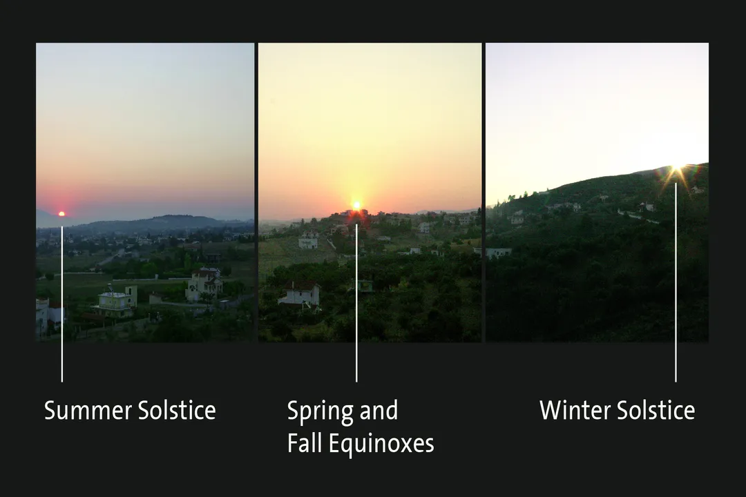
Outside of the equinoxes, the exact point on the horizon where the sun appears or disappears shifts noticeably. [5] This variation is directly tied to the Earth's axial tilt of about $23.5$ degrees relative to its orbital plane around the sun, which causes the seasons. [5]
When a location in the Northern Hemisphere experiences summer, the North Pole is tilted toward the sun. During this time, the sun's apparent path across the sky is significantly higher and longer. [5] This translates to longer daylight hours. The sun rises north of true east and sets north of true west. [5] Conversely, in the Northern Hemisphere's winter, the South Pole is tilted toward the sun. The sun's arc becomes noticeably lower in the sky, resulting in a shorter day. The rising and setting points shift southward; the sun rises south of east and sets south of west. [5] The entire track it takes across the sky looks flatter and closer to the southern horizon for observers in the Northern Hemisphere. [5]
In the Southern Hemisphere, this seasonal effect is mirrored but inverted. During their summer (our winter), the sun traces a very high path, appearing far to the north in the sky. [5] For someone standing near the equator, the seasonal change is less dramatic, but the sun’s path is always near the horizon, moving quickly overhead. [5] At the geographic poles, the situation becomes even more extreme, leading to months of continuous daylight or continuous darkness, rather than a daily cycle. [5]
This means that if you were to use a fixed point on the horizon, like a distant mountain peak, to mark the sunrise location, you would notice that marker shifts substantially over the course of a year. [5] Calculating these precise changes in the solar path for any given location and date is the function of specialized astronomical applications, such as those found on sites like SunCalc or SunEarthTools. [1][6] These tools process the location’s latitude and the date to output the exact celestial coordinates.

# Solar Noon
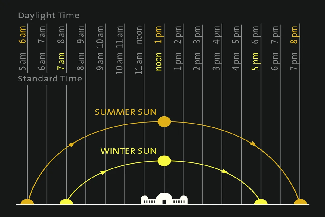
A crucial marker in the sun's daily transit is solar noon, the moment when the sun reaches its highest point in the sky for that specific day. [5] At solar noon, the sun is located due south when viewed from any location in the Northern Hemisphere (or due north when viewed from the Southern Hemisphere). [5] This point is not always the same as $12:00$ PM on your watch or phone. Solar noon depends on your exact longitude relative to the center of your time zone, a concept often referred to as the Equation of Time when accounting for orbital eccentricity. [3]
Because the sun's position at solar noon is tied to the north-south meridian passing directly overhead, it provides an excellent reference point for determining true geographic direction. If you were to stand outside at the exact moment your local solar noon occurred, facing the sun would mean you are looking precisely toward the south (if you are in the Northern Hemisphere). [5] This relationship between solar noon and the meridian is a fixed astronomical reality, unlike clock time which can drift by several minutes depending on how far east or west you are within your time zone’s designated boundaries. [3] For instance, a community on the western edge of an established time zone will experience solar noon significantly later than $12:00$ PM clock time, perhaps closer to $1:00$ PM during daylight saving periods, because their local meridian is far to the west of the standard meridian for that zone. [3]
If we consider a fictional scenario for understanding the effect of latitude, imagine two observers: Observer A is standing at North latitude (like Philadelphia, USA), and Observer B is at North latitude (like Stockholm, Sweden). In the middle of June, Observer A might see the sun at a midday altitude of around above the horizon, a very high arc. [5] Observer B, being much farther north, would see the sun at a much lower midday altitude, perhaps around . [5] This difference in the highest point reached directly illustrates how much further north the sun appears to circle the sky for the observer closer to the Arctic Circle during the height of summer.
# Azimuth Altitude
While the conceptual understanding of rise, arc, and set is helpful, calculating the sun's exact position requires two specific angular measurements: altitude and azimuth. [6] Altitude describes how high the sun is above the horizon, measured in degrees. A value of is the horizon itself, and is directly overhead (the zenith). [6] Azimuth describes the compass direction of the sun, measured clockwise from North, typically for North, for East, for South, and for West. [6]
These two numbers change continuously every second the sun is visible. Many astronomical calculation websites, such as those maintained by NOAA or specialized solar calculation engines, allow users to input a specific latitude, longitude, and time to generate these precise coordinates. [1][6]
For example, if you are at a specific location at $10:00$ AM on a random Tuesday in October, you could use one of these tools to find that the sun’s azimuth might be (meaning it is located in the Southeast quadrant) and its altitude might be above the horizon. [1][6] An hour later, the altitude would have increased, and the azimuth would have rotated clockwise toward the south (closer to ). [1]
When comparing the data generated by tools like SunCalc.org and SunCalc.net, one often finds consistency, as they are modeling the same physical reality—the orbital mechanics of the Earth and Sun. [1][2] Differences in output, if any, usually stem from how they handle the exact definition of "civil twilight" versus "sunrise," or minor variations in how they account for atmospheric refraction, which makes the sun appear slightly higher than it geometrically is when near the horizon. [5]

# Finding Position
Since the path is mathematically determined, anyone can predict where the sun will be, provided they have the essential data points: date, time, and location. [1][6] For someone needing to orient a solar panel array, plan photography around golden hour, or simply determine the path for construction, these tools become indispensable. [1][6]
One practical way to use this information without needing complex software constantly is to establish a local reference point on a day when the path is simpler to remember. If you know the date is near a solstice (June $21$ or December $21$ in the Northern Hemisphere), you know the sun will rise furthest north or furthest south of due east. Observing this extreme point gives you a benchmark. Then, you can track how the sun moves from that extreme point toward the equinox position (due east) over the following weeks. This relative tracking helps build an intuitive feel for the daily shift, even if you don't calculate the precise azimuth to the degree.
For instance, if you know your summer solstice sunrise was at an azimuth of (northeast), and you observe the sun rising at a week later, you can infer that the date is now closer to the equinox, as the rising point is moving back toward the perfect East (). [5] This contrasts with the daily movement, where the azimuth changes by several degrees every hour throughout the day, whereas the rising azimuth changes only gradually over weeks. [5]
# Practical Considerations
It is important to remember that the calculated geometric position of the sun is often slightly different from what the naked eye perceives due to the atmosphere. The Earth's atmosphere acts like a prism and a lens, bending the light rays. [5] This atmospheric refraction is most pronounced near the horizon. This means the sun appears to rise slightly before it has actually cleared the horizon and sets slightly after it has geometrically passed below it. [5] While this effect is usually small (only a couple of degrees), it can be significant when trying to time the precise moment of first contact or last contact for certain scientific measurements or safety observations. [5]
Furthermore, the concept of day length is not simply the time between geometric rising and setting. Astronomically defined twilight periods exist before sunrise and after sunset, when the sky is partially illuminated but the solar disk is below the horizon. [2] Different tools define "sunrise" differently—some use the moment the upper limb of the sun crosses the ideal horizon, while others factor in atmospheric refraction, leading to minor discrepancies between various calculators. [2][5] If you are using an online calculator to determine the best time for a photograph, checking the settings to see if it accounts for refraction can provide an extra minute of usable light planning. A general guide might suggest that when the sun is below the horizon, you are in civil twilight, a time often used for planning outdoor events where some natural light is still desired. [2]
The sun’s track across the sky is a direct consequence of our planet’s consistent, tilted rotation. By understanding the fundamentals—the daily rotation causing East-to-West movement, and the annual orbit around the sun causing seasonal altitude and azimuth shifts—we can move past simple observation to practical prediction, aided by the specialized calculators available today. [1][6]
Related Questions
#Citations
SunCalc - sunrise, sunset, shadow length, solar eclipse, sun ...
Sun Direction: orientation of the sun throughout the day
Day and Night World Map - Time and Date
SunCalc - sun position, sunlight phases, sunrise, sunset, dusk and ...
Sun & Stars Paths - Southern California's gateway to the cosmos!
Calculation of sun's position in the sky for each ... - SunEarthTools.com
Does the sun rise in the East and set in the West for both summer ...
Solar Calculator - NOAA Global Monitoring Laboratory