What does it mean when clouds get dark?
When you look up and see the sky shift from a bright, innocent white to a deep, ominous grey or even black, it certainly catches the attention. It is a near-universal signal that the weather might be changing, often immediately prompting the question: what exactly causes clouds to take on that dark, threatening hue? The answer isn't that the clouds are inherently "black" or filled with some darker substance; rather, it’s a beautiful interplay of physics—specifically, how sunlight interacts with water and ice suspended high above us. [1][4]
# Light Scattering
The foundational reason clouds appear white or light-colored in the first place holds the key to understanding why they sometimes look dark. Clouds are composed of tiny water droplets or ice crystals, and these particles scatter sunlight. [1][3] Sunlight, which appears white to us, is actually a spectrum of different colors. When this light hits the small water droplets, it is scattered in all directions, a phenomenon called Mie scattering. [1] Because these droplets are large enough relative to the wavelength of visible light, they scatter all colors of the spectrum almost equally. [1][3] When all colors are scattered back to our eyes equally, we perceive the cloud as white. [1][3] This is the same reason fog often looks white—it's just a low-lying cloud. [1]
However, this scattering mechanism only applies to the light that successfully reaches the droplets. For a cloud to appear dark, something must prevent that scattered light from reaching the observer on the ground. [1][4]
# Cloud Depth

The most significant factor turning a fluffy white puff into a brooding grey mass is the sheer thickness or depth of the cloud layer. [1][4] Think of a cloud not as a single object, but as a very deep volume of atmosphere filled with these light-scattering particles. [1]
When the cloud layer is thin, sunlight easily passes through, hits the droplets, scatters, and a significant amount reaches the ground, making the cloud look bright. [1][3] Now, imagine that cloud growing vertically, stacking water droplets upon water droplets. As light penetrates the upper layers, it gets scattered away from the path that leads straight down to you. [1] The further the light has to travel through the dense volume of water or ice, the more likely it is to be scattered sideways or absorbed before it can reach the bottom layer. [1][4]
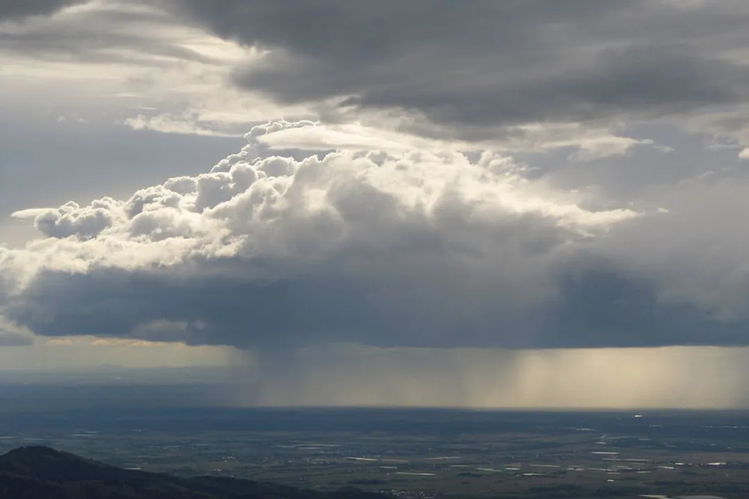
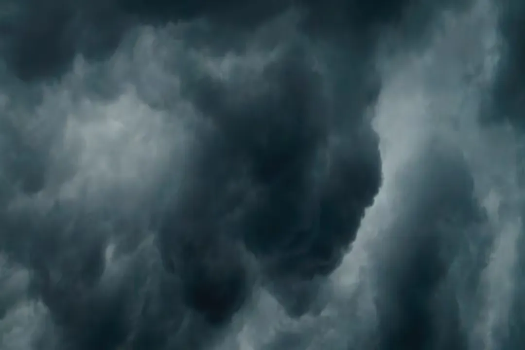
The base of a very thick cloud, therefore, receives very little direct or scattered sunlight from above because the material overhead has blocked it or redirected it away. [1][4] If the cloud base is thick enough and high enough, it can block nearly all the visible light, making the underside appear dark grey or nearly black. [1][8] Rain clouds, which are typically deep enough to produce precipitation, are the prime example of this phenomenon. [4] They hold a large volume of moisture, which equates to a massive number of light-scattering particles stacked vertically. [4]
If you observe a cumulus cloud growing rapidly upwards—a tell-tale sign of instability—and notice the base darkening from the edges inward, it’s not the rain itself making it dark; it's the potential for rain due to the massive depth of water vapor and droplets the light has to struggle through. [4]
# Water Content Versus Ice Content
While thickness is key, the composition within that thickness also plays a subtle role, especially in taller storm systems. Clouds comprised entirely of liquid water droplets tend to scatter light very effectively. [8] However, as clouds grow very tall, like towering Cumulonimbus clouds, the upper portions freeze into ice crystals. [8]
Ice crystals, particularly larger ones, can be slightly more efficient at absorbing certain wavelengths of light than pure water droplets, though scattering remains the dominant process. [8] More critically, very large ice particles or raindrops are much better at scattering light away from the observer below than the tiny droplets that make up thin, white clouds. [8] In essence, the larger the particle (be it a big drop or a large hailstone), the more effectively it intercepts and redirects the incoming solar radiation, contributing to a darker appearance at the base. [8]
# Implication of Darkness
The most immediate, real-world implication of a cloud appearing significantly dark is the high probability of precipitation. [1][4][7] Dark storm clouds are usually a sign that the cloud is deep and dense, meaning it has condensed a substantial amount of moisture ready to fall. [4][7]
# Rain Clouds
Clouds that are consistently dark, such as Nimbostratus clouds, often signal steady, prolonged rain or snow. [7] These layers are horizontally extensive and quite thick, producing precipitation that lasts for hours. [7] Their darkness stems from that continuous, light-blocking depth.
# Thunderstorm Clouds
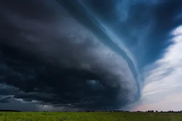
The darkest clouds, often appearing almost black or even greenish-tinged (though the physics of green is separate), are the bases of Cumulonimbus clouds—the engines of thunderstorms. [4][7] These are defined by their enormous vertical extent. The sheer column of water and ice within a severe thunderstorm is so vast that the base is almost completely shadowed from the sun, creating that intimidating, near-black look. [4][7] If you see a cloud base this dark, you should be prepared for heavy rain, strong winds, and potentially hail or lightning. [7]

# Non-Rainy Darkness
It is certainly possible for clouds to look strikingly dark without any immediate rainfall occurring directly overhead or within sight. This happens when the conditions that create darkness—namely, light blockage due to density and depth—are present, but the air below the cloud base is too dry, or the upward motion (lift) isn't strong enough to sustain the precipitation down to the ground. [2][6]
One common scenario involves the sun's position. If the sun is low on the horizon, for instance during sunrise or sunset, the light has to travel through a much longer stretch of atmosphere to reach the cloud and then travel back to you. [3] Clouds directly opposite the setting or rising sun can appear dramatically dark because the sunlit side is facing away from you, and the remaining ambient light is heavily filtered by the atmosphere itself. [3] In this case, the darkness is more about the viewing angle relative to the light source than the immediate atmospheric threat. [6]
Another situation involves virga, which is precipitation that evaporates before hitting the ground. [2] A deep, moisture-laden cloud can look incredibly dark because it is producing rain high up, but the air underneath is dry, causing the rain to vanish mid-fall. [2] From the ground, you see the dark base of the rain-producing cloud, but the rain never materializes at your location. [2]
Consider this observational distinction: A dark cloud that has a relatively flat, uniform base and is moving slowly is likely Nimbostratus signaling prolonged drizzle or steady rain. [7] Conversely, a dark cloud base that is rapidly boiling upwards, perhaps with visible rotation or defined turrets, is a Cumulonimbus, suggesting intense, but potentially shorter-lived, bursts of severe weather. [4][7]
# Comparing Light Attenuation
To put the physics into a practical perspective, consider how light attenuates through different media. While sunlight through a cloud is primarily scattering, we can draw a useful comparison to simple absorption. Water in a clear glass appears colorless because the path length is short. A full swimming pool looks blue-green because the light path is long enough for the water molecules to absorb the red end of the spectrum selectively.
Clouds follow a similar path-length dependency. A thin, wispy Cirrus cloud, made of ice crystals high up, is semi-transparent, letting most light pass through, hence they appear bright white or translucent. [1] A mid-level Altostratus cloud may appear greyish, indicating moderate depth and light blockage. [3] But a deep Cumulonimbus is like looking through an incredibly thick wall of water—the light is scattered so many times and so far from the observer's line of sight that the base is effectively in shadow, appearing black. [1][4]
# Estimating Rain Intensity
Observing the shade of grey can sometimes offer an impromptu forecast for a local observer. While it’s not an exact science without radar, local experience can guide interpretation. Clouds that are a very light, almost pale grey might indicate that the cloud is deep enough to produce light rain or drizzle, but the light penetration is still relatively good. [1] These clouds often hover just above the threshold for significant rainfall.
If you notice the darkness concentrating in the center of a developing storm cloud, spreading outward, this suggests the core is reaching its maximum vertical development and moisture content. [4] A general rule of thumb, derived from the physics of light blockage, is that the more uniform and darker the grey on the underside of a cloud mass approaching you, the heavier and more sustained the precipitation is likely to be once it arrives, as it implies a greater depth of liquid water across a wider area. [4] The very darkest patches often correlate with the most intense updrafts and, consequently, the heaviest downpours or hail cores within the storm structure. [7]
# Atmospheric Stability and Darkness
The appearance of dark clouds is deeply tied to atmospheric dynamics, specifically stability. Dark, towering storm clouds require significant atmospheric instability—warm, moist air rising rapidly high into the atmosphere. [4] This rapid upward movement allows the cloud to build great vertical mass quickly, leading to that profound darkness near the base. [4]
In contrast, a cloud system that darkens gradually over many hours, like a widespread sheet of Nimbostratus, suggests a less violent but more extensive lifting mechanism, such as a warm front overriding cooler air. [7] The darkness here is derived from persistent, steady saturation across a vast volume rather than the explosive vertical growth seen in thunderstorms. [7] In essence, the energy of the atmosphere dictating the cloud's structure is visibly translated into the amount of sunlight it can absorb or deflect away from the ground observer. [1][3] Understanding the shape accompanying the darkness helps distinguish between a powerful, short burst of severe weather and a long, steady soaking rain.
The sheer visual impact of a dark sky is a primal cue, but knowing that this darkness is purely a function of geometry and light transmission—a vast, dense shadow cast by water overhead—provides a much richer appreciation for the mechanics happening miles above us. [1][4]
Related Questions
#Citations
Why Are Rain Clouds Dark?
What causes dark clouds when there's no rain or storms?
The Color of Clouds
Breakdown: Why storm clouds usually appear dark
Dark clouds often indicate approaching rain or thunderstorms
Do black clouds ever indicate anything other than pending ...
This is what gives storm clouds their dark appearance
Why are rain clouds darker?