What do dark clouds foretell?

The shift in the sky, a sudden darkening that seems to swallow the usual bright blue, naturally prompts us to look for an umbrella. Dark clouds are perhaps the most universally understood, if sometimes misinterpreted, sign in the sky. They signify density, moisture, and often, an impending change in the weather, yet the color itself can be deceiving. Understanding what these shadows truly forecast requires looking past the simple binary of "dark means rain" and delving into the physics of light and the life cycle of the cloud itself. [6][2]
# Cloud Opacity

The deep gray or near-black appearance of a cloud is fundamentally an optical phenomenon tied to how much light it scatters and how much it absorbs and reflects back toward the ground. [2] All clouds form when water vapor condenses onto tiny particles, like dust or salt, creating visible water droplets or ice crystals. [2] The key difference between a bright white, fluffy cloud and a menacing dark one lies in the size and concentration of these particles, and consequently, the cloud's depth. [4]
When a cloud layer is thin, sunlight passes through relatively easily, scattering the light effectively, which makes the cloud appear bright white. [2] However, as water droplets grow larger and the cloud becomes thicker and taller, less light is able to penetrate all the way to the base. [4] The water droplets at the top and middle of the cloud reflect and scatter the sunlight back up into space, away from an observer on the ground. [2] What we see as darkness is essentially the shadow cast by the upper layers of the cloud, meaning the base appears dark because very little light is reaching it from above. [4] This effect is more pronounced in towering clouds where the vertical development is significant, like mature thunderheads. [2]
# Storm Indicators

Different types of dark clouds point toward distinctly different weather scenarios. The general rule taught to many is that the darker the cloud, the more water it holds, thus suggesting a higher likelihood of precipitation. [8]
One common dark cloud associated with steady, prolonged precipitation is the nimbostratus cloud. [8] These clouds often appear as a vast, featureless, dark gray sheet covering the entire sky. [8] Their darkness signifies significant vertical extent and high moisture content, typically bringing continuous, light-to-moderate rain or snow over a wide area, without the dramatic severity often linked to darker, more imposing shapes. [8]
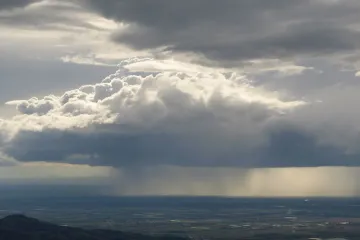
In contrast, the most dramatic dark clouds are cumulonimbus formations, the architects of thunderstorms. [4] These clouds are characterized by immense vertical growth, sometimes reaching the top of the troposphere. [2] Their bases are often flat and extremely dark due to their sheer mass and depth. [4] When observing these, the darkness is not just due to thickness but often accompanied by turbulent structure and a menacing ceiling, indicating powerful updrafts and the potential for heavy rain, hail, strong winds, and lightning. [4][8]
Another layer to consider is the altostratus cloud, which can appear grayish or bluish-gray. [8] While these can sometimes be precursors to widespread rain within the next several hours, they are generally less indicative of immediate, heavy downpours than their lower, thicker cousins, the nimbostratus or the base of the cumulonimbus. [8]
It is a fascinating exercise to note the speed of the darkening; a slow, uniform descent of gray across the sky, like a vast, lowering ceiling, is a very different forecast than the rapid, boiling ascent of a dark, turbulent mass that seems to push the brighter sky away from its edges. [10]
# Separating Shadow from Rain

The biggest source of confusion about dark clouds is the assumption that darkness equals immediate rain. Many people wonder why a cloud can look profoundly dark yet offer nothing but dry air when they stand under it. [6] The reality is that darkness indicates potential moisture content, but not the immediate stage of precipitation. [1]
For rain to fall, the water droplets or ice crystals within the cloud must grow large enough through collision and coalescence that they overcome the atmospheric updrafts holding them aloft and gravity pulls them to the ground. [2] A very thick, dark cloud may simply have droplets that are numerous but still too small to fall as rain. [6] The cloud is optically dense, but microphysically immature in terms of droplet size. [1]
One helpful way to interpret this situation is by looking at the horizontal extent versus the vertical energy. [10] If you see a massive, dark sheet stretching from horizon to horizon with no defined towering tops—a classic nimbostratus—the rain is highly likely to be widespread and relatively steady, perhaps already falling just a short distance away, making the entire region appear darker. [8] Conversely, if you see isolated, dark-based towers that look like anvils beginning to form, the heaviest precipitation will be concentrated directly beneath that specific cell, while the air immediately beside it might remain dry, even if the sky looks ominous. [1]
An original analysis of local contrast: If you are standing in an area where the sky directly overhead is dark gray, but you can clearly see patches of bright blue or white clouds on the eastern horizon, this contrast often suggests that the active weather system is localized or moving quickly. The darker patch overhead is likely rain-bearing but relatively shallow or perhaps passing its peak intensity. If, however, the darkness is uniform and the edges of the cloud deck are higher than the center, suggesting a deep, expansive system, the system has more inertia, and the rain will likely be more persistent once it begins.
# Reading the Edges

To move from a general warning to a specific prediction, observers must pay close attention to the cloud's edges, structure, and associated features, rather than relying solely on the base color. [10]
# Structure and Height
Look for clear indicators of vertical development. Bright white areas juxtaposed against the dark base suggest strong vertical motion; the sunlight is still powerfully reflecting off the tops, meaning the cloud is actively growing and may yet produce heavier precipitation. [2] If the entire cloud is uniformly dark from bottom to top with no bright tops visible, it suggests the cloud has reached its maximum stable altitude or is beginning to dissipate, often meaning the heaviest weather has already passed or is less severe. [4]
# Associated Features
Specific features signal imminent severe weather when associated with a dark base:
- Mammatus Clouds: These pouch-like formations hanging underneath the base of a dark cloud often signal severe turbulence within the cloud structure, usually associated with mature or collapsing thunderstorms. [8]
- Shelf Clouds: A low, horizontal, wedge-shaped accessory cloud often seen attached to the base of a thunderstorm, known as an arcus cloud, always signals a strong gust front is approaching, meaning high winds and heavy rain are minutes away, regardless of the exact shade of gray overhead. [8][2]
The presence of these accessory structures adds a layer of urgency that simple darkness lacks. A dark sky can mean a steady drizzle; a dark sky with defined, turbulent features means sudden, intense weather.
An actionable tip for assessment: When assessing incoming dark clouds, take note of the apparent speed of the cloud bases relative to the higher cloud structures (if visible). If the low, dark bases are moving significantly faster than the higher, sometimes lighter mid-level clouds, it suggests strong, varying wind shear within the atmosphere. This shear fuels instability and often means the potential for organized, severe weather, even if the base doesn't look as menacingly piled up as a classic cumulonimbus at first glance. This dynamic structure is often more important than the static color.

# Contextual Clues
While the physical appearance provides the what, the environment provides the when and how much. A dark cloud appearing on a hot, humid summer afternoon following several hours of building heat and bubbling cumulus clouds has a much higher probability of turning severe than the same-looking cloud that drifts in behind a cold front on a cool, windy day. [10]
Furthermore, the time of day offers context for cloud behavior. Clouds that develop and darken late in the afternoon are often fueled by the day's peak heating, leading to stronger updrafts and more intense, localized storms. [1] Clouds that arrive in the morning or early afternoon, especially if they are associated with a larger front system, are more likely to produce prolonged, steady precipitation. [8]
Ultimately, observing dark clouds is about building a holistic picture. The darkness signals that a significant amount of moisture is suspended aloft, making a change in weather probable. [2] However, the ultimate forecast—whether that moisture materializes as a gentle shower, a day of steady rain, or a violent thunderstorm—is written in the cloud’s shape, its movement, and the atmospheric conditions surrounding it. [10]
#Videos
Why Storm Clouds Are Dark - YouTube
Related Questions
#Citations
What causes dark clouds when there's no rain or storms? : r/weather
9 Types of Clouds and Their Differences - Climavision
Why Storm Clouds Are Dark - YouTube
This is what gives storm clouds their dark appearance - WQAD
ASVAB Word Knowledge Question 299: Answer and Explanation
When the cloud is dark, does it always mean it's about to rain? - Quora
Scarlet Letter (4) Flashcards - Quizlet
Cloud Guide: Types of Clouds and Weather They Predict!
Beyond Pretty Pictures: How Clouds Can Help You Predict the ...