How do scientists know how big the Earth is?
Figuring out exactly how big the Earth is required more than just looking at the horizon; it demanded a sharp mind, basic geometry, and a willingness to accept that the world wasn't flat. For millennia, the size of our planet was subject to philosophical debate, but by ancient times, the framework for a correct measurement was in place, long before telescopes or satellites made the task easier. [3][5] This story of measurement is a testament to human observation, moving from simple shadow lines in the Egyptian desert to the incredibly precise measurements taken by instruments orbiting high above the atmosphere today. [8]
# Ancient Setup
The conceptual leap required to measure the Earth was accepting that it is, in fact, a sphere. [5][9] Once that was assumed, the problem reduced itself to trigonometry and knowing a fixed distance on the surface. [3] The ancient Greeks understood the Earth was round, but quantifying its circumference was the real challenge. [5] While there are several methods people have conceived for gauging Earth's size—from timing how long it takes light to travel between two known points to using the horizon dip from a known height—the most famous and successful early attempt centered on shadows and wells. [7]
# Eratosthenes Calculation
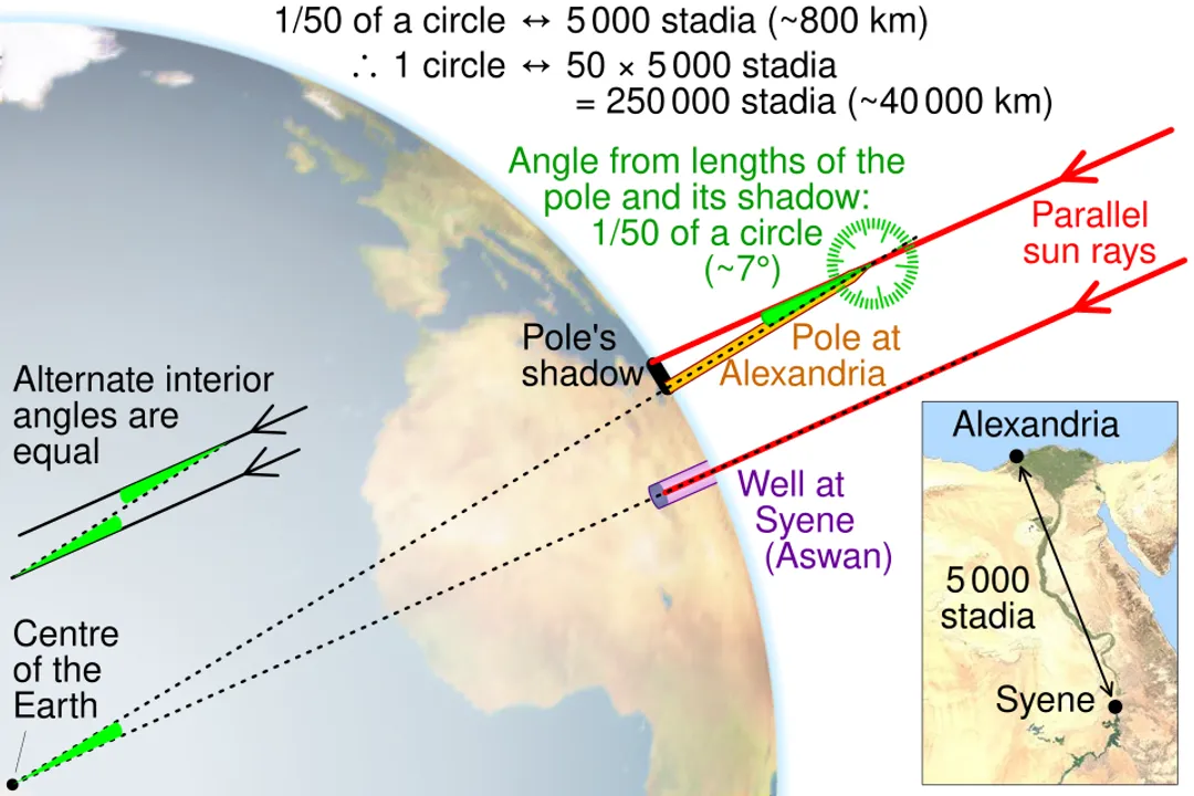
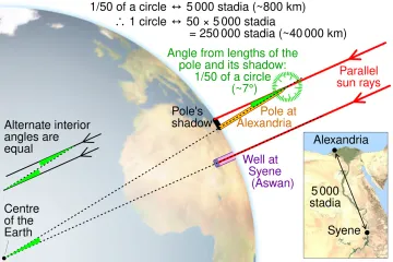
The story often centers on the Greek scholar Eratosthenes around the third century BCE in Alexandria. [5][9] He heard a fascinating piece of information about the city of Syene (modern Aswan), which lay nearly due south of Alexandria. [5] At noon on the summer solstice, the Sun was directly overhead in Syene; vertical sticks cast no shadow, and sunlight reached the bottom of deep wells. [5][9]
When Eratosthenes replicated this observation in Alexandria on the same day and time, his vertical stick did cast a shadow. [5] This difference in shadow length was the key, demonstrating that the Earth's surface was curved. [5] If the Earth were flat, the sun would have appeared at the same angle in both locations. [3] Eratosthenes correctly reasoned that the angle of the shadow he measured in Alexandria was equal to the angle between Alexandria and Syene as viewed from the Earth's center. [5]
# Shadow Angles
The measurement relied on two critical pieces of data: the angle of the shadow and the distance between the two cities. [5] Eratosthenes found the angle of the shadow cast by an obelisk (or gnomon) in Alexandria to be about . [5] This angle represents a fraction of a full circle, which is . [5] Since $360$ divided by $7.2$ equals $50$, he concluded that the distance between Alexandria and Syene must be exactly one-fiftieth of the Earth's total circumference. [5]
The distance between the cities was estimated to be about 5,000 stadia. [5] Multiplying this distance by 50 gave him the total circumference: 250,000 stadia. [5] Depending on which unit of stadia he used—a measurement whose exact modern equivalent is debated—his result was remarkably close to the actual figure. [5] For instance, if using the common Attic stadia, his calculation yielded a circumference of about 39,690 kilometers, which is only about 1% different from the modern accepted value of roughly 40,075 kilometers around the equator. [2][5] Carl Sagan noted this astounding accuracy achieved without sophisticated instruments, suggesting that Eratosthenes calculated the circumference to within about 0.5% to 2% of the true value, depending on the precise length of the stadion used. [9]
If we take the modern equatorial circumference of , [2] and know that Eratosthenes measured th of that total, we can calculate the distance between the cities he should have used for perfect accuracy: . His reported distance of 5,000 stadia, when converted to the commercial Greek stadion, translates to about 787.5 km. This small difference—about 14 kilometers out of an 800-kilometer stretch—is a phenomenal achievement for a single researcher using only shadows and foot travel estimates. [3]
# Post-Ancient Refining
While Eratosthenes provided a foundational figure, subsequent thinkers refined the measurement, often dealing with the practical challenges of long-distance surveying. [8] Early methods sometimes involved measuring the difference in the time it took for the sun to reach its highest point at two different latitudes, which is essentially an extension of Eratosthenes' principle. [1]
Other historical approaches focused on longitude rather than latitude differences. For example, measuring the time difference between astronomical events observed simultaneously at two geographically separated locations helped establish the angular difference between them, which could then be related to a known surface distance. [7] However, measuring precise surface distances, especially across large bodies of water or rugged terrain, remained difficult. [8] The act of surveying longitude accurately proved far harder than measuring latitude, contributing to significant errors in early attempts to map the globe accurately. [8]
# Geodesy Modernizing
Today, the science dedicated to measuring and understanding the Earth’s precise geometric shape, orientation in space, and gravity field is called geodesy. [8] This field has moved far past shadow sticks and surveying chains. [7]
Modern techniques rely on space-based observations to achieve centimeter-level accuracy. [8] These include:
- Satellite Laser Ranging (SLR): Ground stations fire lasers at orbiting satellites equipped with retroreflectors and measure the time it takes for the light to return, providing precise distances. [7]
- Global Positioning System (GPS) and Global Navigation Satellite Systems (GNSS): By analyzing signals from multiple satellites, precise coordinates and elevations can be determined almost instantly anywhere on the globe. [7][8]
- Very Long Baseline Interferometry (VLBI): This technique uses radio signals from distant quasars observed simultaneously by widely separated radio telescopes to measure extremely accurate Earth rotation and tectonic plate movements, which are integral to defining the Earth's shape over time. [7]
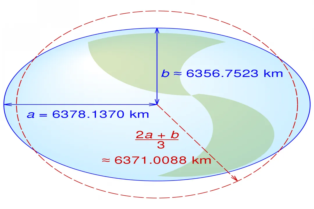
These methods confirm that the Earth is not a perfect sphere, which would have a constant radius everywhere. [4] Due to the planet's rotation, the centrifugal force causes an equatorial bulge. [4] Therefore, the Earth is best described as an oblate spheroid. [6]
# Defining Dimensions
The precise size of the Earth depends on which measurement you take, reflecting its slightly squashed shape. [4][6] Because of the bulge at the equator, the distance from the center to the equator is longer than the distance from the center to the poles. [4]
Here are the generally accepted figures derived from these advanced geodetic techniques:
| Measurement Type | Value (Kilometers) | Value (Miles) |
|---|---|---|
| Equatorial Circumference | ||
| Polar Circumference | ||
| Equatorial Radius | ||
| Polar Radius | ||
| [2][4] |
When scientists refer to the "average" radius, they often use the value (about ). [6] Furthermore, the true physical shape, accounting for local gravitational variations caused by mountains, trenches, and mass differences in the crust, is called the geoid, which is the actual shape the ocean surface would take under the influence of Earth's gravity and rotation alone, ignoring winds and tides. [8] The gravitational models used to map this geoid are continually refined by newer satellite missions. [8]
The sheer volume of data collected today allows scientists to create highly detailed models of the planet, informing everything from high-precision navigation to fundamental physics research. [7] This contrasts sharply with the methods of James Bradley in the 1700s, who used stellar aberration—the apparent shift in the position of stars due to the Earth’s orbital motion—to estimate the speed of light, which in turn helped refine the Earth's known dimensions through geometry. [1] While Bradley was focused on speed, the underlying geometry that connects celestial motion to terrestrial measurement demonstrates the interconnectedness of these early scientific endeavors. [1]
# Tracking Progress
It is fascinating to compare the different epochs of measurement, not just in terms of accuracy, but in terms of the effort required. [8] Eratosthenes required a long walk or a dedicated courier between two cities and a single measurement of sun angle. [9] Hundreds of years later, surveyors needed massive, carefully chained baselines and towers to create triangulation networks across continents. [8] Today, a network of ground stations and satellites works continuously, often achieving data accuracy that surpasses the best historical estimates by orders of magnitude, all while requiring no physical movement from the scientist operating the computer processing the signals. [7][8] This shift represents moving from reliance on local, visible phenomena to a global, systematic measurement system tied to space itself. [6]
Related Questions
#Citations
How did mankind first determine the size of the Earth? | Science Guys
Earth's circumference - Wikipedia
ELI5 How the first people to measure the circumference of earth do it?
The Earth - Imagine the Universe! - NASA
5.4: Measuring the Earth with Eratosthenes - Physics LibreTexts
How big is Earth? - Space
10 ways to measure the size of the Earth - Interesting Engineering
The History of Geodes: Global Positioning Tutorial
How an ancient polymath first calculated Earth's size, as told by Carl ...