How is the Vredefort Dome still visible?
The fact that we can still trace the outline of an impact structure from an event that happened over two billion years ago is genuinely astonishing. The Vredefort Dome, situated in the Free State province of South Africa, stands as the largest and oldest known impact structure on Earth, a colossal scar left when an asteroid or comet struck the planet about 2.02 billion years ago. [1][4] When we ask how it remains visible today, we are really asking how any evidence of such an ancient, massive collision survived the relentless geological forces of deep time. The answer lies in a dramatic story of initial violence, subsequent erosion, and the differential resistance of the underlying bedrock.
# Impact Scale
To appreciate the survival of the dome, one must first grasp the sheer scale of the original event. Current estimates suggest the impacting body created a transient crater that measured perhaps 250 to 300 kilometers in diameter. [1][2] Think of that size: it dwarfs many modern city-states. The impact was so energetic that it didn't just excavate material; it violently compressed and fractured the crust beneath it, driving rock upwards in a massive, temporary rebound, which ultimately formed the structure we observe now. [1][7]
This initial excavation left behind a landscape that would have been utterly unrecognizable—a vast, deep depression surrounded by a shattered rim structure. [2] For comparison, the much younger and famous Meteor Crater in Arizona is only about 1.2 kilometers across; Vredefort was exponentially larger. [4] The energy involved was immense, capable of generating high-pressure minerals that can only form under extreme conditions, such as shocked quartz and shatter cones. [1][7] These geological fingerprints are crucial evidence, confirming the immense force involved, even after the original topography has vanished. [7]
# Erosion's Toll
The primary reason the Vredefort Dome isn't a perfectly preserved bowl like younger impact sites is simple geography and time. At roughly 2.02 billion years old, Vredefort pre-dates the earliest recognizable fossils by nearly a billion years. [1][4] Over these immense spans—billions of years—the Earth’s surface constantly remodels itself through wind, water, ice, and tectonic forces.
In the case of Vredefort, erosion has been devastatingly effective. It has stripped away virtually all traces of the original rim and the outer crater structure. [1] What we see today is not the original crater but the deeply eroded, central portion of the structure. [7] If the impact had occurred, say, 50 million years ago, we would likely be looking at a massive, preserved circular depression. Because it happened so long ago, nearly 10 kilometers of overlying rock have been removed from the center of the structure. [1] This deep stripping process is what reveals the internal architecture of the impact site.
The erosion process acts like a geological knife, cutting down through layers of material. Imagine a layered cake where the center has been violently pushed up and cracked. If you let rain and wind wear down the cake for two billion years, the softer, outer layers of frosting and sponge will be washed away, leaving behind the structurally harder, uplifted core. This is essentially the fate of the Vredefort impact zone. [7]

# Central Uplift
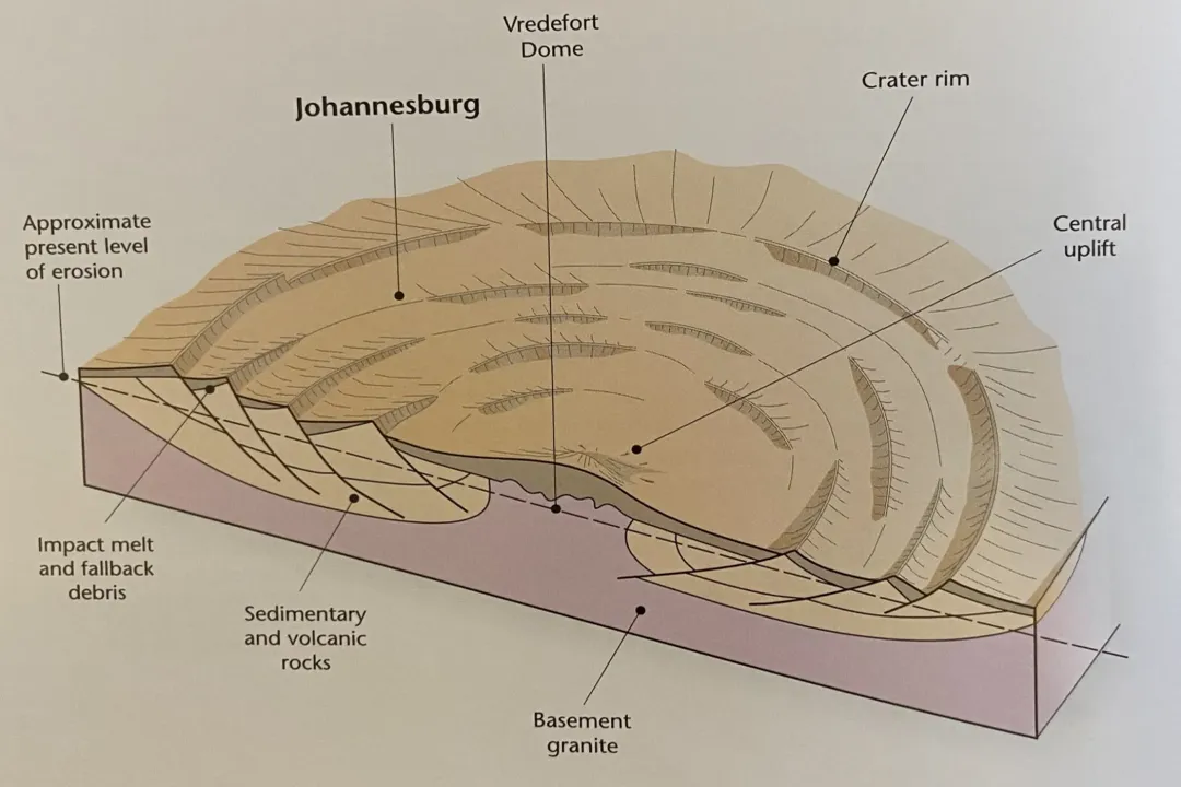
The feature that remains visible, the Vredefort Dome, is the remnant of that initial central uplift—the core that rebounded after the impact. [1][7] This central dome consists of basement rocks—ancient, hard metamorphic and igneous rocks—that were squeezed upward during the event. [1] These rocks are now fractured and metamorphosed due to the extreme pressures. [7]
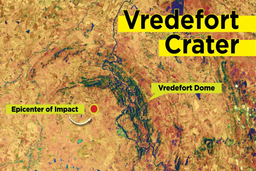
The structure visible today is not a circular depression but a subtle, elliptical topographic feature spanning about 70 kilometers in diameter. [1][6] It is defined by the way these resistant, uplifted rocks interact with the younger sedimentary and volcanic strata that have accumulated around and over them since the impact. [1] While the original rim is gone, the resistance of the uplifted basement rocks to subsequent erosion has allowed them to persist longer than the surrounding, perhaps softer, rock layers that once covered them. [7]
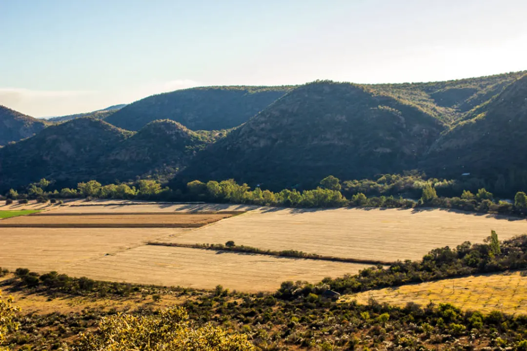
One interesting point to consider when observing the dome is the contrast between its visual appearance and its origin. Younger impact craters often present as distinct, sharp rings or basins. [2] Vredefort, however, is visible primarily as a subtle disturbance in the modern landscape, a low-lying, dome-shaped area where the underlying geology has been forced up, resisting the general erosion that leveled the surrounding terrain. [7] This topographic signature, rather than a sharp crater wall, is the key to its current visibility from the ground and even from space. [8]
# Shock Evidence
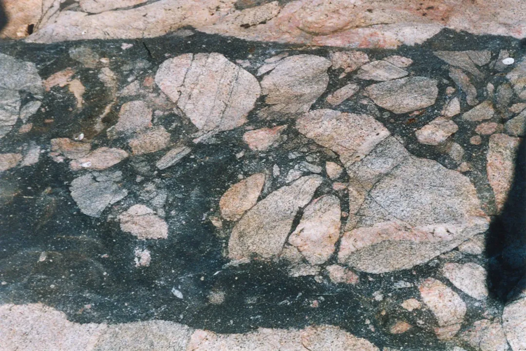
The visibility of the Dome isn't just about the structure's shape; it's also about the indelible chemical and physical marks left behind, which allow scientists to confirm its origin, especially where topography has failed to persist. [7] The presence of shatter cones—conical fractures in rock caused by extreme pressure—is a smoking gun for impact events. [1] Furthermore, the discovery of shocked quartz—quartz grains with internal deformation features created only under shock pressures—solidifies the impact hypothesis. [1][7]
These shock features are less affected by surface erosion than the topography itself. While erosion might remove the kilometer-high rim, it cannot easily erase the atomic structure of quartz grains deep within the uplifted basement rock. When geologists study the Dome today, they are not just looking at hills and valleys; they are analyzing these microscopic or localized features that testify to the violence of the event, thereby proving the feature is the crater remnant, even if it doesn't look like one. [7]
# Ground Visibility
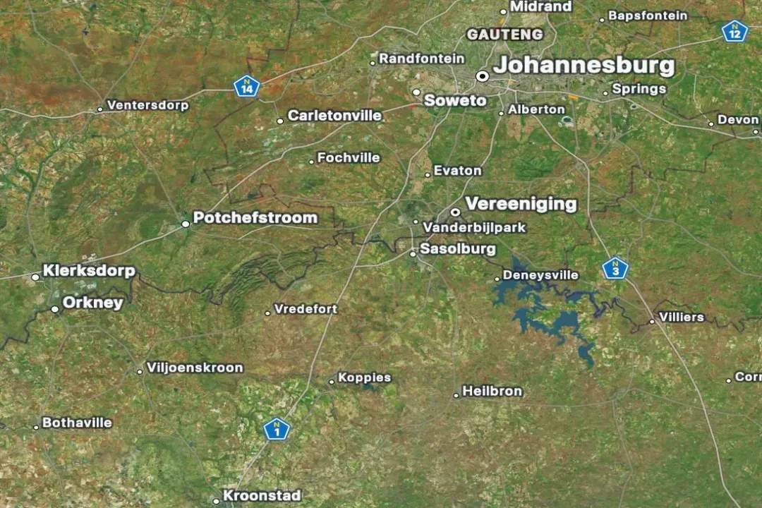
From the ground level, the visibility of the Vredefort Dome can be deceptive. It is not an obvious, textbook crater rim that one might see from an airplane over a younger site. [8] Instead, observers in towns like Parys or Vredefort witness a landscape molded by geology that has been profoundly altered by the impact, but not preserved in its original form. [5][6] The structure is now classified as a UNESCO World Heritage Site, largely due to its scientific significance as an ancient, deeply eroded impact structure. [1]
If you were standing at the center of the uplift, the land would gently rise toward you. [7] If you were standing on the outer edge of what used to be the rim, you would be standing on much younger sedimentary cover rock that has since been deposited over the edge of the original structure, with the ancient, uplifted core materials hidden beneath. [1] This suggests that modern viewing relies on recognizing the subtle dome structure and the geophysical anomalies beneath the surface, rather than distinct physical topography. For instance, ground penetrating radar or magnetic surveys reveal the circular pattern of the fractured basement rock extending far beyond the visible topography. [1]
Considering the vastness of the structure and the deep erosion, it’s interesting to note the time required for geological processes to obscure such a massive feature. If Earth’s average erosion rate over the last 2 billion years has been consistent—a generous assumption, of course—the amount of material stripped away speaks to the overwhelming power of steady, slow forces against a single, violent event. The fact that the central uplift survived is a testament to the intrinsic strength and density of the deep crustal rocks forced upward during the central rebound phase. [7] Unlike the softer sedimentary layers, these metamorphosed basement rocks possess greater shear strength, slowing down the rate at which erosion could wear them down to the general level of the surrounding plains.
# Space Perspective
The question of visibility often extends to satellite imagery, and yes, the Vredefort structure is still discernible from space. [8] While the original, distinct rim might not be apparent, the overall circular pattern caused by the uplift and subsequent erosion remains visible in remote sensing data. [8] This is where the structure’s vast size becomes an asset. Even with substantial erosion, a feature spanning hundreds of kilometers leaves a noticeable signature on the topography that is picked up by orbital instruments. [1]
Images often highlight the elliptical shape of the visible dome, which has an axial ratio of about 1.5 to 1. [1] This slight elongation, rather than a perfect circle, is attributed to tectonic stresses acting on the structure after the initial impact. [1] Seeing this subtle, immense ring from an orbital perspective confirms that the geological history, though millions of years in the making, has left an unmistakable scar on the planet's surface, distinguishable even when viewed against the backdrop of modern sedimentary cover. [8]
# Comparing Structures
To truly understand the visibility of Vredefort, it helps to compare it to other known terrestrial impact structures. The Ries impact crater in Germany, for example, is significantly younger—about 15 million years old—and retains a much clearer, albeit heavily eroded, circular depression. [4] Similarly, the Barringer Crater (Meteor Crater) is barely 50,000 years old and its walls are still sharp. [4] These younger sites show us what Vredefort looked like shortly after impact.
Vredefort’s status as the oldest known large impact site means it offers a unique look into the long-term geological fate of such features. [4] Its visibility is not that of a preserved hole, but that of a geological ghost—a vast, elliptical area of structurally disturbed basement rock that has been forced to express itself topographically through differential erosion over eons. [7] This makes studying Vredefort a masterclass in deep time geology, showing how the most dramatic geological events can leave behind only subtle hints after a couple of billion years, hints that require expert interpretation rather than simple observation. [1] It’s a monument to endurance, etched into the continental crust itself. [4]
Related Questions
#Citations
Vredefort impact structure - Wikipedia
Vredefort Crater - NASA Science
[OC] Vredefort Dome (asteroid impact site) 3D Topographic Map
Vredefort Crater, Largest and Oldest Known Impact Crater
Vredefort Impact Structure, South Africa | EROS
Vredefort crater: largest asteroid impact structure visible today
The Vredefort impact - VolcanoCafe
Is the Vredefort crater visible from space? - AstroPhysics Zone - Quora
Asteroid that formed Vredefort crater bigger than previously thought